
Introduction
The Philippines is an island country made up of more than 7,500 islands located in the northeast of Southeast Asia and on the west coast of the Pacific Ocean. Since population settlement began about 30,000 years ago, indigenous Malays have been introduced around AD, forming self-sustaining villages called ‘barangays’. After the 14th century, Islam was introduced to the southern Sulu Islands and Mindanao Island, and in the 16th century, its influence extended to Luzon Island, where some small Islamic kingdoms were formed.
In 1521, Portuguese navigator Ferdinand Magellan (1480–1521), sponsored by Spain, first landed on Cebu Island in the Visayas. Afterwards, it was declared a colony by Miguel Lopez de Legazpi (1502-1572) in 1565, and the country was named ‘Philippines’ after the King of Spain at the time.
As a result of the Spanish-American War in 1898, it was colonized by the United States and was also ruled by Japan during World War II. Actual independence occurred in 1946, but the Philippine government officially celebrated Independence Day in 1898, when it declared independence from Spain. Due to the influence of Spain, it acquired the religion and culture of the Roman Catholic Church, and due to the influence of the United States, it acquired the characteristics of a presidential system and the use of English as the official language. Diplomatic relations with Korea were established in 1949, and the Philippines dispatched 7,420 soldiers during the Korean War.
Society of Philippines
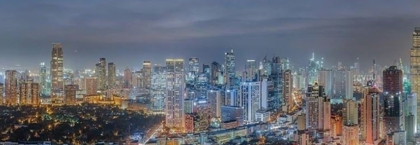
The urbanization rate in the Philippines has remained at 47% since the 1990s. The urban population has increased by more than 22.9 million people over the past 30 years (1990–2020), but the population growth rate in rural areas is slightly higher. However, the concentration of population in the metropolitan area is high. Metro Manila, the capital of the Philippines, is the largest city in Southeast Asia, with a population of over 12 million.
Over the past 30 years, in the Philippines, one city with a population of 1 to 5 million people, 11 cities with a population of 50 to 100 million people, and 13 small and medium-sized cities with a population of 300,000 to 500,000 people have also increased. The population of the metropolitan area, mostly surrounding the capital, Metro Manila, has increased rapidly. Although the population of the Philippines’ capital city is less than 13% of the total population, the gross domestic product (GDP) concentration rate exceeds 37%, so a significant portion of the national economy is dependent on the capital city.
The Philippines established the “Philippine Development Plan” (2017–2022) starting in 2017 and was the first to introduce a National Spatial Strategy (NSS) that considered economic growth, population trends, and spatial characteristics in the socioeconomic blueprint. In addition, the Philippines emphasized the role of cities as a driving force for economic growth and poverty reduction through its long-term national plan, Vision 2040. However, plans to resolve concentration in the metropolitan area or promote balanced development of the country are still unclear. President Rodrigo Duterte promised to revise the federal constitution to solve the problem of ‘Metro Manila becoming an empire’, but there was no move to realize it during his term.
Topography of the Philippines
As the Philippine Islands are located in the Pacific Rim orogenic belt, orogeny and volcanic activity are active, and as a result, the topographical structure of mountains, plains, coasts, and trenches is complex. For this reason, each island is generally composed of mountain ranges in the north-south direction, with a narrow coastal plain between them. In addition, the geological distribution of the Philippine Islands mainly consists of volcanic rocks and coral reefs, but most geological structures and rocks can be identified.
The topography of Luzon Island, the largest island in the Philippine archipelago, also consists of mountain ranges in the north and south and coastal plains in between. The northeastern part of Luzon Island consists of the lowlands of Cagayan Valley, which extends in a north-south direction, with the Cordillera Central Mountains in the west, the Sierra Madre Mountains in the east, and the Caraballo Mountains in the south. It has a surrounding shape. The western part of Luzon Island, where large cities such as Manila are located, includes the Zambales Mountains and Central Luzon Plain, where Mount Pinatubo (1,486m), famous for its massive eruption in 1991, is located from the west, and the northeastern part of the country. It consists of the southern end of the Sierra Madre Mountains. Southern Luzon Island has volcanoes that are irregularly distributed, and Mayon Volcano (2,462m) is famous. Mindoro Island in southern Luzon consists of a north-south mountain range and a coastal plain surrounding it. Palawan Island, southwest of Luzon, is about 400km long in the southwest-northeast direction but only 40km wide, and the average altitude of the upper part of the mountain range along the long axis of the island reaches 1,100m, with the highest peak being Mount Mantalangahan. Mantalingahan, 2,086m).
The topographical structure of the Visayas is unique for each island, but the mountain ranges all have a north-south mountain range structure except for Bohol Island and Samar Island. The major peaks of the Visayas mountain ranges reach altitudes of over 1,800 m above sea level, with the highest peak being Canlaon Volcano (2,465 m) on Negros Island.
Mindanao Island can also be seen as being mainly composed of mountain ranges in the north and south directions, but it has a unique shape compared to other islands in the Philippines. In the eastern part of Mindanao Island, the Diwata Mountains-Eastern Pacific Cordillera and the Central Mindanao highlands rise in an east-west direction, and the Davao-Agusan lowlands are located between them. In central Mindanao, there is the Cotabato basin, the Mindanao Central highlands in the east, the Tiruray highlands in the south, and the Bukidnon-Lanao plateau in the north. Located. On the western side of Mindanao Island, the Zamboanga peninsula extends in a southwest direction, which leads to the Sulu Islands and all the way to the Malaysian island of Borneo.
Major cities
The capital of the Philippines is legally the City of Manila, but it is reasonable to view the actual capital as Metro Manila (NCR), a metropolitan city comprised of 17 cities and counties, including Manila. As of 2019, there are a total of 146 cities in the Philippines by administrative division. Among them, 33 cities are ‘highly urbanized cities (HUC)’, 5 are ‘independent constituent cities (ICC)’, and the rest have the status of ‘constituent cities (CC)’.
In order of size, Quezon City (approximately 2.96 million people), which is part of Metro Manila, is followed by the City of Manila (approximately 1.85 million people) and Davao (1.77 million people), the representative city of Mindanao Island. . Cebu City, the representative city of the Visayas region and the tourist capital of the Philippines, has a population of approximately 960,000.
Other major regions include Angeles, a former U.S. military base on Luzon Island and now a special economic zone; Cavite Province, an industrial hub; Baguio, a tourist hub in the northern region; and Palawan Island, a major marine tourism destination. Examples include Boracay Island.
Conclusion
It is an island country in Southeast Asia and a representative Catholic country in Asia. Immediately after World War II, it maintained the second-highest economic level and democratic development in East Asia after Japan, but national development stagnated due to the long-term rule of Ferdinand Marcos. Democracy was restored through the popular uprising in 1986.